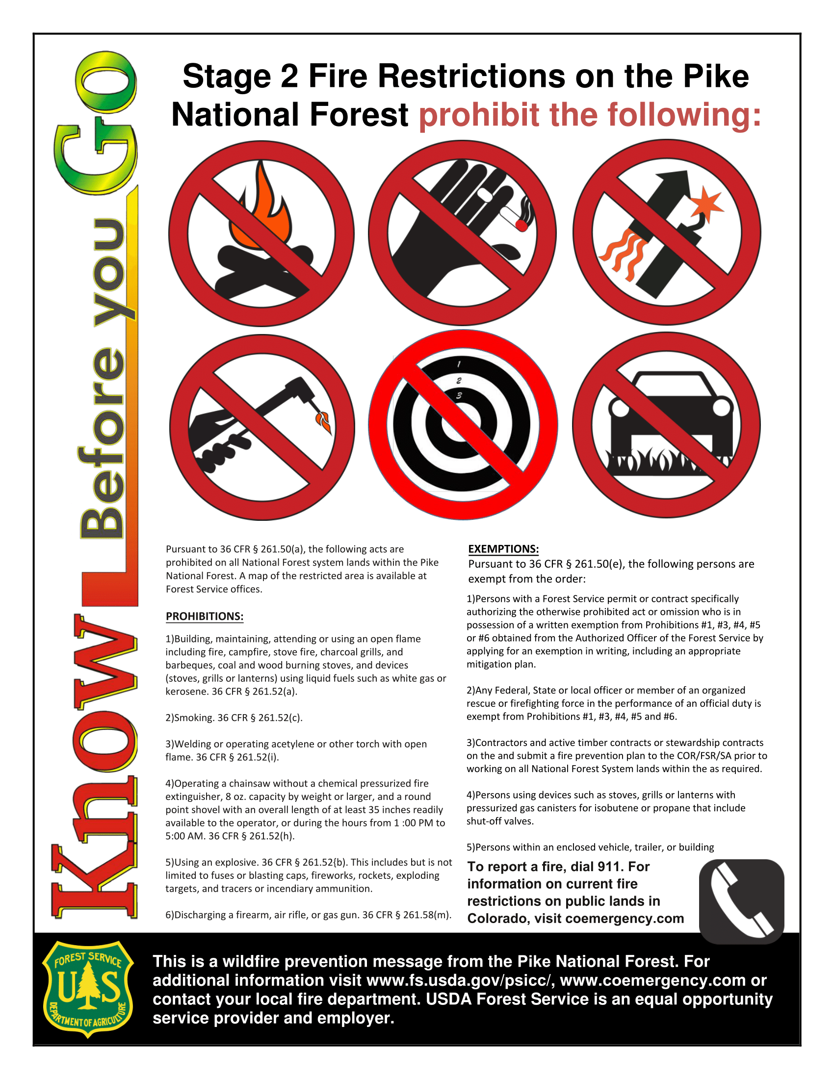
For a cleaner version read the uploaded pdf file => Stage 2
For a cleaner version read the uploaded pdf file => Stage 2
Just in time for Memorial Day weekend!
—
The U. S. Forest Service (USFS) announced Tuesday that it expects to open over 40 percent of the Waldo Canyon Burn Area to visitors Friday, May 24, 2013.
The opening will include the Rampart Reservoir Recreation Area trail, campgrounds, picnic sites and National Forest System Roads 307, 311 and 313 (also known as the Schubarth Road).
According to District Ranger Alan Hahn, “Since the Waldo Canyon fire, we have accomplished a considerable about of work at the recreation sites and the trail around the Reservoir. Our goal is to provide a safe environment for forest visitors.”
Next Spring, forest managers will re-evaluate and determine if additional acres can be open to the public.
The remainder of the Waldo Canyon Burn Area will be closed until further notice.
The Waldo Canyon Trail #640 is not open because the steep valleys pose public danger during a major rain event which could trap visitors in low lying areas, according to the USFS.
Small water craft with electric motors can be launched from the shore at Rampart Reservoir. Visitors are cautioned that the water level at the Reservoir is expected to be low and the boat launch and ramp will be closed. No boats or motor vehicles will be allowed to cross the dam. Nichols Reservoir, south of the dam, is empty and is included in the new Closure Order. Stanley Canyon Reservoir is also empty.
Public safety is a challenge because of the Burn Area’s proximity to Colorado Springs and heavy visitor use in the past.
Violators are subject to a maximum fine of $5,000.
The revised Waldo Canyon Fire Closure Special Order and map will be located on the web at:http://www.fs.usda.gov/alerts/psicc/alerts-notices/?aid=14836.

Mt Herman Rd Re-open Map Click to Zoom
It has been a chaotic couple of weeks in the area and we have up to date information on what is open, what is closed, maps, orders, and volunteer opportunities!1. Open or Closed?
At the top of everyone’s mind … what is open and what is closed?
The good news, the Preserve is OPEN! Despite some signage to the contrary it is open. We’ve worked witht the USFS to correct the signage and post maps. You do need to steer clear of Mt. Herman Rd – the machinery working on the road can throw rocks and debris 200+ feet – so stay away from the road. USFS 715 “Stoopid Trail” is closed where it turns SW in the SQ corner of the preserve. We have placed a sign there – that leads you into the closure – stay out or risk a ticket.
The bad news, Mt. Herman Rd and everthing West of Red Rocks Rd to Palmer Lake and then West on 322 to Rampart Range Rd is CLOSED. There was a new order in place as of Friday closing this section.
Why: So that the Forest Service can finish cleaning up the fire line on Mt. Herman Road – they are using masticulating machines and feller bunchers and they are also removing all the logs from the Mt. Herman Rd fire line. This will continue for several more days at the very least, maybe a couple of weeks. We hope that it will re-open after that but we have no firm date or commitment from the USFS yet. If we get one we will let you know.
Please have a look at this zoomed in map of our area from the latest USFS closure order.

Full map and closure order (Adobe PDF Reder required), these are somewhat large, be patient:
Waldo Canyon Fire Area Closure Order 12-08
Waldo North Closure REVISED map
A list of other regional openings and closings is at the end of this email/post.
2. Fire
We still have high fire danger so be aware. The recent rains have not changed the fire danger.
3. Shooting Range Update
After FOMP volunteers cleaned up over 60 (yes 60!) bags of trash and debris from illegal shooting on Mt. Herman Rd the FS then cleaned up just as much 2 days later and closed parking and roped off these areas. There was approximately 2 acres total sutdown to shooting in areas that are not safe to shoot in the first place. Social ranges that were on the top of ridgelines with not backstop were closed down. Much, muc more remains to be done to make Mt. Herman Rd a safe place for other recreational users as some of the remaining social ranges have been utterly destroyed and shooters are shooting uphill with stray and ricochet bullets landing in Limbaugh Canyon still as well as on the Mt. Herman hiking trail. We continue to work with the USFS to try and make the Mt. Herman corrider a safe place again. The illegal shooting is just that – illegal and unsafe. It is in areas where shooting is allowed unfortunately many (and it appears a majority) of the recreational shooters on Mt. Herman Rd choose not to follow the rules of the USFS and are destroying trees and other resources as well as creating very dangerous situations for themselves and others. FOMP’s BOD continues to work with the USFS for good solutions for all parties including recreational shooters.
4. Monthly Trail Work Session Information
FOMP is pleased to be holding a volunteer trail work and tree trimming work session!
FOMP==== List of Known Open / Closed Regional Trails ====
Thanks to David Wagner for putting this list together – we will try and update it as he provides updates and eventually make it a seperate post on www.fomp.org
Open:
Falcon Trail (Air Force Academy) with military ID update: The Falcon Trail (Air Force Academy) is only under FPCON ALPHA, so only drivers license is required — update #2: Falcon Trail may be only partially open unless you have a military ID – please verify before you go!
Trail Closures due to the Waldo Canyon Fire:
For official news and the latest updates on the Waldo Canyon Fire see the multip agency Incident Information System “InciWeb”. InciWeb has information about all current and past fires. Active fire are updated as information becomes available.
InciWeb home: http://inciweb.org/
Waldo Canyon Fire: http://inciweb.org/incident/2929/
Thanks
FOMP
From the Pike NF Home Page
http://bit.ly/eolkWr
Stage 1 Fire Restrictions – Pike and San Isabel National Forests
Sorry for yesterday’s short notice to those planning on attending the hot shot crew pot luck dinner. We received word at 4:30 that the crew needed to go to a fire near Divide. That fire is now apparently under control and we are expecting the crew to be back late this afternoon. So, we are going to re-schedule the dinner for this evening at 6:00 PM in the fire center classroom building. Thank you everyone for your flexibility.
For those folks unfamiliar, FOMP throws the hot shot and helitac crews stationed in the Preserve an appreciation dinner every year as they begin their season. If you would like to join us and meet these fine folks please feel free – and if you can bring a dish of any kind go for it.
So, 6:00 PM tonight May 8 in the classroom building – the first building on your right when you enter the work center.
Questions – please call Chris Tirpak at 719.439.8865